
GREENSBORO, N.C. — The odds of North Carolina dealing with a winter storm this weekend are going up, and the WFMY News 2 Weather Team is on top of it. As usual, there are a lot of moving parts when it comes to a winter weather forecast, so it's important to keep checking back throughout the week as details will change.
Winter weather set-up
So, why do we think winter weather will be possible this weekend? Let's explain.
First, cold air will be heading our way Friday, which sets the stage for a cold weekend and leaves open the door for winter weather. As we often say, the best way to get snow in the Carolinas is to have cold air in place first. We will have that this time. Next up, you need to have moisture.
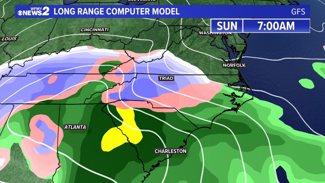
As it happens, low pressure appears to be tracking our way by Saturday night or more likely Sunday. It could bring a lot of moisture, which would fall either as snow, sleet, ice, and some rain -- more likely a combination of those.
Snow or a wintry mix?
There's a fine line between whether a storm would simply be rain and snow, or if it's going to have snow, followed by an icy mix, and then rain. The latter, messier setup is looking more likely this time. We just don't know where the snow zone, ice zone, and rain zone will set up at this time, but that will become more clear in the next couple of days.
It is clear that heavy wintry precipitation is likely pretty much all day on Sunday. That means whether it's more snow or more ice, we're looking at a big deal storm either way.
Travel disruptions expected
It's becoming more clear that travel is going to be a big problem on Sunday. You can plan for roads to go downhill almost immediately once the snow starts falling before sunrise. Any sleet or freezing rain throughout the day will only make things worse.
Difficult roads will not easily improve without crews plowing and salting. This means that neighborhood streets may remain a big mess for several days.
Snow models
This has a lot of the looks of significant winter storms that we've tracked here in the Piedmont in the past. So, if you're a snow lover, there's reason to be excited - even though some sleet or ice could crash and ruin some of the fun. We'll know more about that later in the week.

TIMING:
- Mostly dry Saturday (can't rule out an afternoon or evening snow shower, but mostly dry and good for preps)
- Snow moves in overnight Saturday into Sunday morning
- Stays mostly snow in the Foothills and mountains through Sunday night
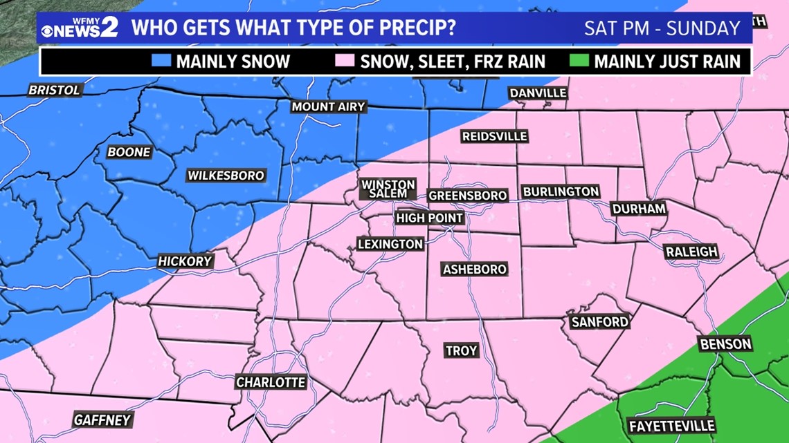
- Changes to sleet / freezing rain midday Sunday in much of Triad and southern Piedmont
- Storm exits Sunday night
- Cold and dry Monday / Tuesday / Wednesday
HOW MUCH:
With how "wet" the system looks, there's potential for this to be a big storm for parts of the Carolinas. Both big snow totals and big ice totals are still possible, but highest snow amounts should be expected in the foothills and mountains, with bigger ice amounts farther south and east.
Areas to the north and west of the Triad will have the better chance at seeing the most snow from this system, and most precipitation will likely fall as snow in these areas. In the Triad, it's more likely to see a period of snow, then snow and sleet mix. The Triad could even see a period of freezing rain Sunday afternoon. South and east of the Triad a better chance for icing will occur.

IMPACTS:
- Difficult travel is looking more likely for Sunday.
- Travel problems could linger a while depending on how much we get.
- Power issues could arise if we get ice along with any snow.
Stay up to date with the WFMY News 2 Weather Team and the News 2 Weather App for constant updates as they prepare you for the winter weather weekend.
RELATED: Driving in winter weather