GREENSBORO, N.C. — Winter weather has arrived in the Piedmont. The big question is, how much snow, sleet, and ice can you expect in your neighborhood? The risk for freezing rain and icing appears to be increasing.
RELATED: Winter Storm | Live team coverage
Here's the latest forecast from the WFMY News 2 Weather Team:
Bottom line, Sunday is going to be a bad day of weather. A winter storm is on the way that will deliver an icy mix to our area all day. It will start as snow in the early morning, then transition to sleet and freezing rain as the day goes on. We will need to closely monitor the freezing rain threat as it appears to be increasing. This, combined with possible 35 mph wind gusts could lead to power outages. Travel will be very difficult. It's going to be a mess that may take a while to be cleared up.
What's the timing?
- Snow moves in early Sunday morning towards daybreak
- Changes to sleet and freezing rain by midday across much of the Triad and Piedmont
- Snow lingers a bit longer in the Foothills and Mountains before switching to some sleet
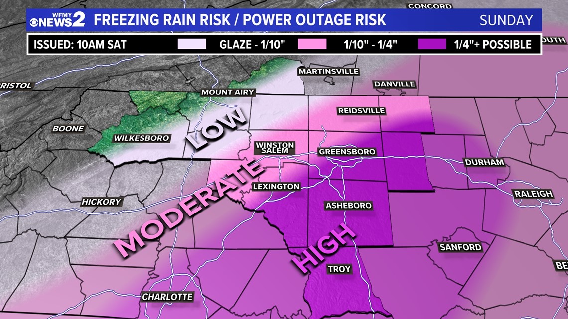
- Areas from the Metro Triad and to the south may get .25" to .50". This combined with wind gusts to 30 to 35 mph could lead to widespread power outages
- Storm exits Sunday night
- Cold and dry Monday / Tuesday / Wednesday
How much snow and sleet and ice:


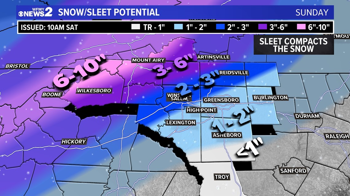
Remember, we're really not calling this a "snowstorm" - more of a "winter storm". The reason being, we're going to see snow and sleet, plus freezing rain. When sleet mixes in with snow it packs it down, making it icier and less fun overall. So, our forecast reflects those compacted totals and may be lower than some of the national apps that you're seeing.
- Mountains and Foothills: Highest snow totals will be here. Over 6-10 inches is possible in the areas that stay snow the longest.
- Most of the Triad, including Greensboro, Winston-Salem, High Point, and Lexington: A broad area of 1-2 inches of packed snow and sleet is possible. Will need to watch for some accumulating ice.
- Areas north and west including Yadkin, NW Forsyth, Stokes, NW Rockingham: Around 4 to 6 inches of heavy snow and sleet.
- Areas south and east of I-85: Lower amounts of snow and sleet are likely here, as much as 2 inches, but as little as 1 or less is possible. This area has the potential to get significant icing.
The potential for freezing rain is there for Sunday afternoon. Areas in the southern Piedmont and eastern Piedmont have the biggest risk in our area to see some significant ice. The darker shade of pink on the map indicates where the biggest risk for power outages would be - which may be scattered in this storm.


How high are the winds?
Wind gusts will be an issue. We're expecting gusty winds all day, which could reach 25-40 mph throughout the day.
Gusty winds could make for a higher risk of power outages especially considering trees that may be weighed down with snow, sleet and ice.
What are the main impacts?
Q&A with Chief Meteorologist Tim Buckley:

