
GREENSBORO, N.C. — It was the storm that had no name. It may not have been tropical, but it sure was a big problem for some across North Carolina. But who got hit the hardest? Who was spared? This storm was a hard one to figure out. We dive into the details all across North Carolina.
Different Impacts, Different Places
The main idea with this storm is that impacts were very localized. Meaning - they varied a whole lot from one area to the next. Take this map below as an example. It shows the extreme rainfall was confined to a few county area along the coast, with a second extreme area closer to home here in the Piedmont near the Virginia border, and another along the Outer Banks.
For the most part, all other areas avoided truly severe weather. The impacts were not severe in much of the Triad or Triangle of the Piedmont. In fact, the rain was beneficial after a few dry weeks of weather.

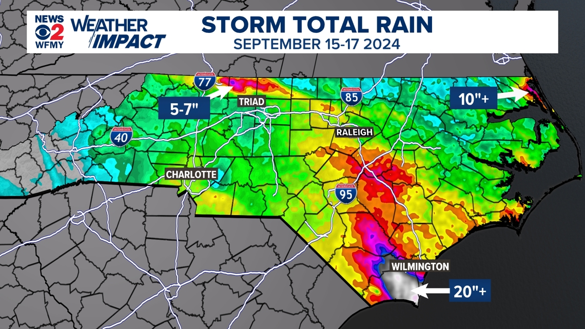
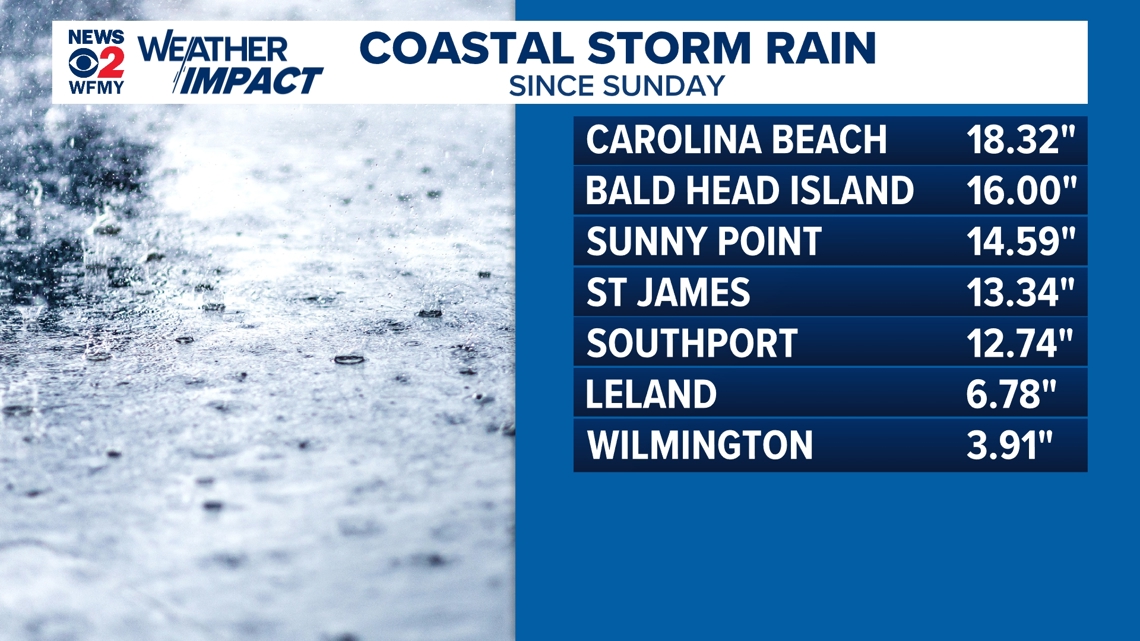
Beginning at the coastline, flooding rain bands started late Sunday night and didn't let up until Monday evening. Rain totals measured mainly between 15-20" across southeastern NC mainly in Brunswick County.

Not much in the Triad, but flooding in Rockingham & Stokes
In the Triad, rain began impacting southernmost counties Monday morning then became more steady at times in the afternoon and evening. Rain continued overnight into Tuesday in Greensboro, dropping a total of 1.09" on Monday then 1.26" on Tuesday. Wind gusts mainly stayed in the 25-35 mph range.
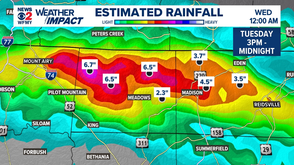
Later in the afternoon Tuesday, a rain band was able to redevelop and strengthen just north of Greensboro--creating problems for residents of Stokes and Rockingham counties. Very narrow heavy rain bands set up and stalled over a few areas. These aren’t able to be easily forecast - so it changed two counties of our area from “no big deal” to roads washing away.
Radar estimates in the 9 hour timespan between 3pm - midnight in Stokes and Rockingham were in the 4-7" range causing significant flooding in both counties. Multiple roads in both counties became impassable due to flooding.

A water rescue on Wolf Island Road saved two people--their car washed into a corn field. Reidsville rescue, Eden rescue, Swiftwater team Oregon Hill volunteer FD and others helped in the effort.
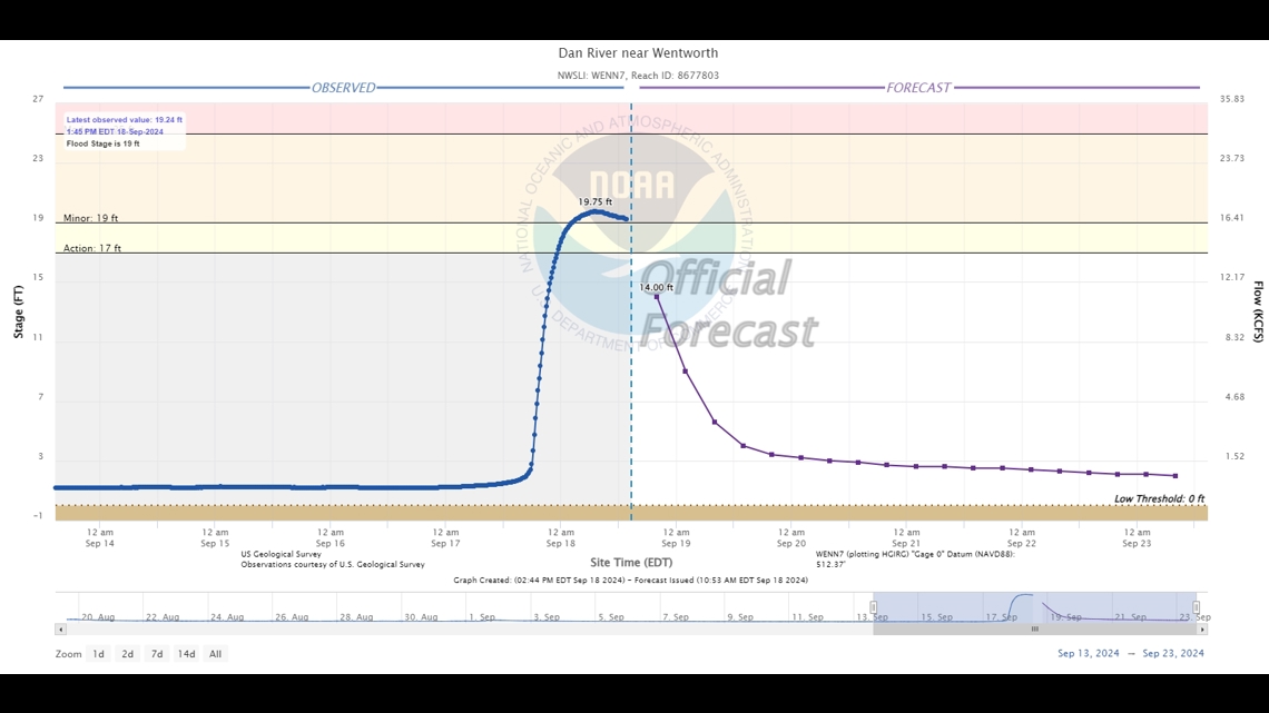
Rivers and creeks were also significantly impacted. The Dan River rose approximately 16.4 feet between 3pm Tuesday and 12:30am Monday morning.

The good news: rain chances have died down and will be isolated this evening and Thursday/Friday. We'll be mainly dry but humid into the weekend. For the latest forecast, head on over to this link.

MORE WAYS TO GET WFMY NEWS 2
Download the WFMY News 2 APP from your Apple or Google Play store.
ADD THE WFMY+ APP TO YOUR STREAMING DEVICE
ROKU: Add the channel from the ROKU store or search for WFMY.
Amazon Fire TV: Search for WFMY to find the free app to add to your account. You can also add the app directly to your Fire TV through your Amazon account.