
GREENSBORO, N.C. — Debby will begin to impact North Carolina as early as Tuesday as it wiggles northward through midweek. We need to pay attention and monitor the forecast for changes. The WFMY News 2 Weather Team is tracking it as it slowly gets closer.
Debby Makes Landfall
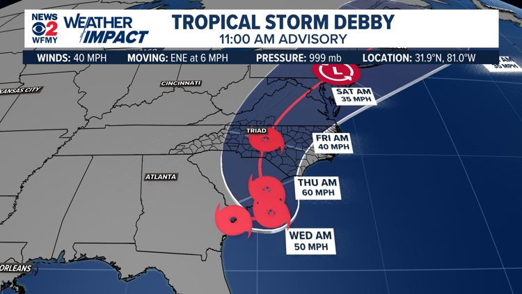
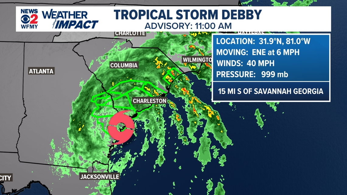
Hurricane Debby made landfall along the Big Bend in Florida early Monday. The storm will move northeastward but will slow down as it does. The storm is already beginning to slow down and will likely stall near Charleston, SC by Tuesday, Wednesday, and maybe Thursday. It is still unclear exactly where it will stall.

Impacts Across The Southeast U.S.
It is likely Debby will move back over the Atlantic waters by Wednesday into Thursday where it could regain some strength. A second landfall is possible along the Carolina coast Thursday - possibly as a tropical storm or hurricane. It will likely be out of our area by Saturday night, clearing for Sunday.


Flooding will continue to be an issue across the southeast as the system loses its forward speed and stalls. Slow-moving tropical systems are especially dangerous for inland flooding that they can bring. The biggest problem with Debby is likely to be flooding rainfall for the inland areas, even if we don't know exactly where yet.
In the past, slow-moving tropical storms or hurricanes have dumped over 10 inches of rain in the Carolinas on multiple occasions in recent years. This could be another one of those times.
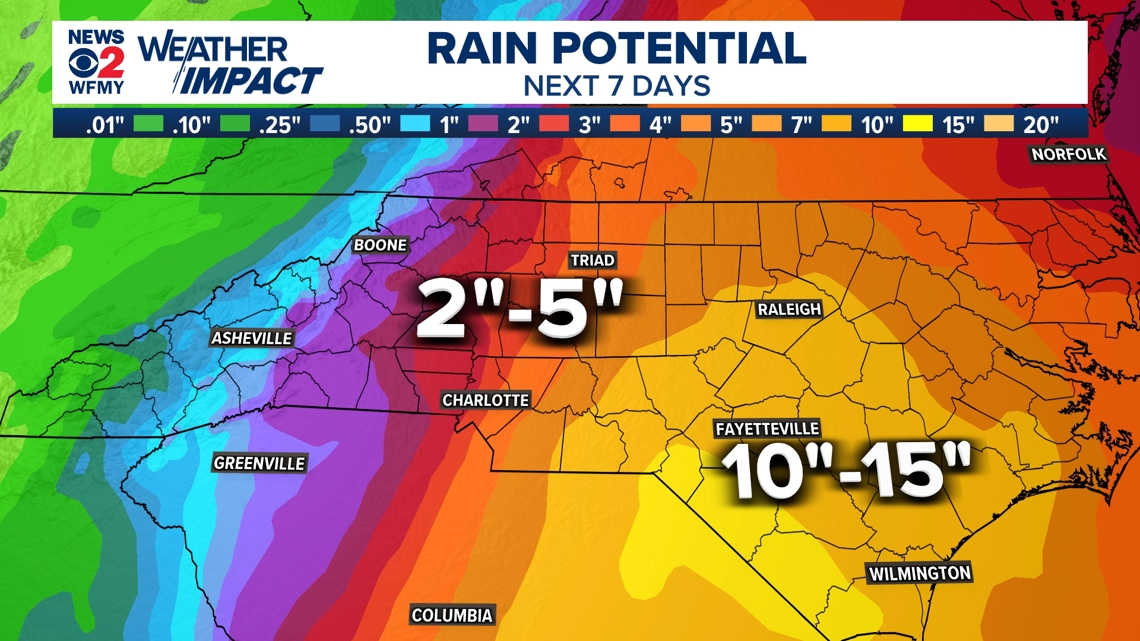
Here is a rainfall forecast from the National Weather Service, which is certain to change accordingly with Debby's track.

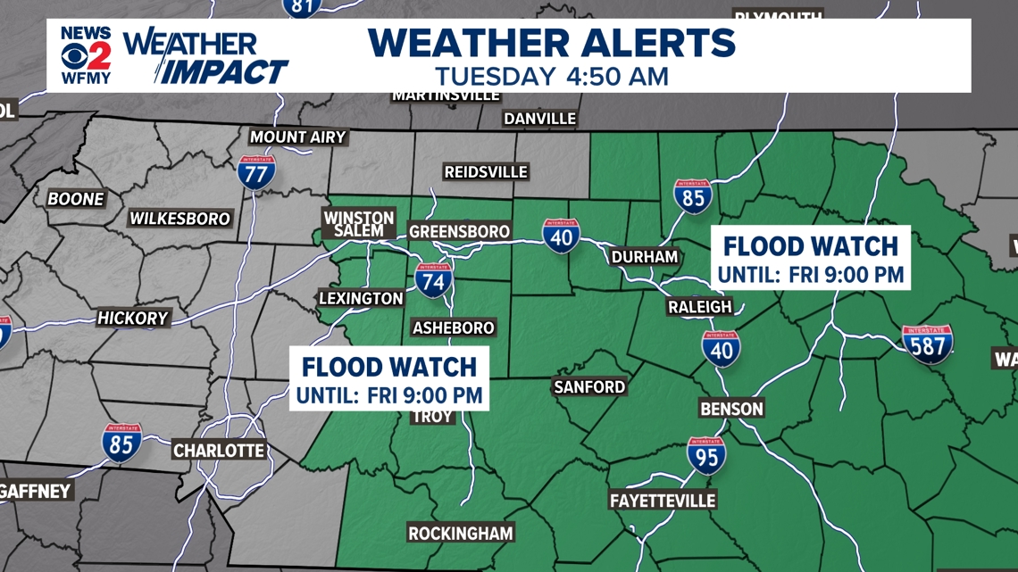
A Flood Watch will go into effect Tuesday at 9 a.m. for most of central and eastern North Carolina. The greater threat for flooding will be Thursday and Friday.

It is appearing more and more likely that here in the Piedmont, we could see some heavy rain or even wind if Debby is able to move further enough inland. 2-4" is a safe bet, with up to 6-7"+ in heavier bands from Debby. Wind gusts could be from 30-40 mph at times Wed - Fri, but the main threat will continue to be flooding.
Along the coastline, other tropical impacts are likely, including up to 10-15" of rainfall. Storm surge, damaging winds, big waves, and a tornado risk are all possibilities.
It's important to take this storm seriously. This storm is slow-moving and will cause issues for flooding all over the southeast, especially for South Carolina. Although the Greensboro area will get wet and breezy at times, the flood threat here is lower than to our south and east. Conditions will improve for the weekend but expect possible lingering road closures, power outages, and flooding for some days.


The concern for strong gusty winds is increasing as the forecast track is more westward. The low pressure of Debby could track north across the Triad Friday and Friday night. Gusts of 35 mph to 45 mph+ are possible. This could cause scattered power outages.