

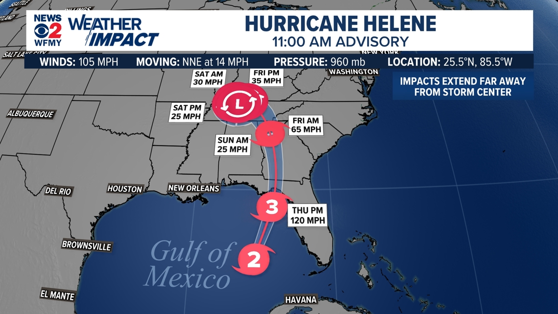
GREENSBORO, N.C. — There's not much time to prepare if you're in Florida. Helene is now a hurricane and will continue to strengthen into a major hurricane before it hits the Gulf Coast along the Panhandle tonight Thursday. Here in North Carolina, the WFMY News 2 Weather Team is tracking the storm too to see what impacts from rain and wind we could see as the storm moves northward on Friday to end the week. They expect rough rain and wind at times and have issued a WFMY News 2 Weather Impact Alert Day.
Helene Moving North
Hurricane Helene is moving towards the Big Bend area for Northern Florida.
Given the warm water and favorable conditions, we are expecting development to happen fast.
The current forecast from the National Hurricane Center calls for Helene to be close to a major hurricane before hitting Florida tonight. (A major hurricane is Category 3 strength or higher)

Helene Timeline:
- Helene becomes a major hurricane today
- Helene hits Florida as a major hurricane tonight
- Here in NC, scattered rain and storms without much wind for Wednesday and Thursday
- Helene moves inland Thursday night into the Southeast, rain and wind spread into Georgia and the Carolinas
- Worst weather for North Carolina happens on Friday morning and midday with gusty winds and heavy rain bands and an isolated tornado threat
- Improving conditions Friday afternoon
- No concerns Saturday aside from lingering impacts
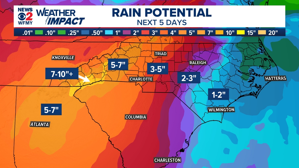
Rain for Thursday and Friday:
On and off downpours have been with us and will continue for today and Thursday. This tropical moisture can drop a lot of rain quickly and will keep the ground saturated. 1 to 2 inches is likely between these days alone.
On top of that, Helene will move our way on Friday with heavy rain bands that will add a widespread 1 to 3 inches on top of what has already fallen.
In the mountains, some extreme rainfall totals are possible and flooding is very likely. Farther east in the state rain will be less common and totals will be lower.
Check out the map below. This highlights how the wind and rain could move northward after Helene hits Florida.

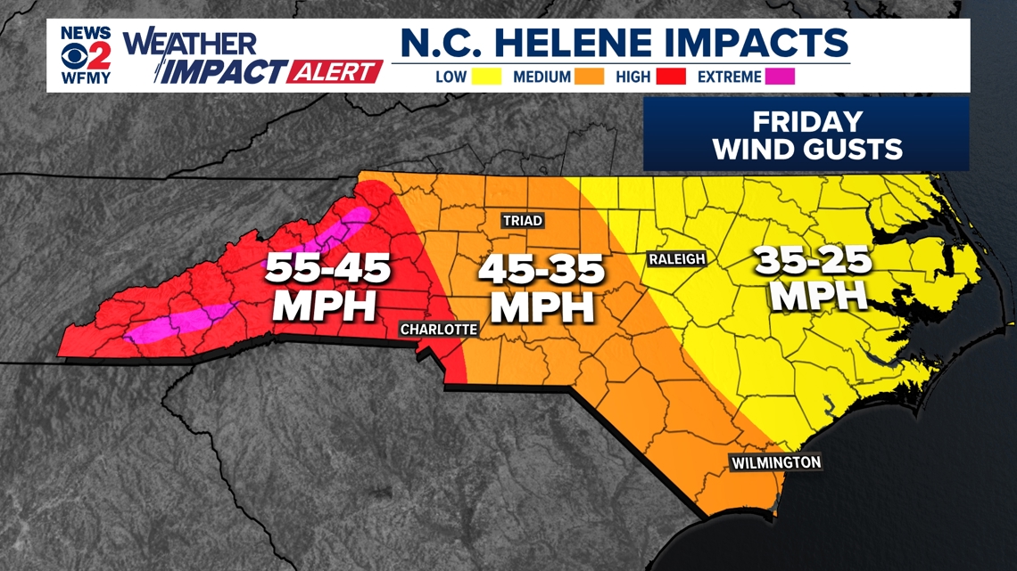
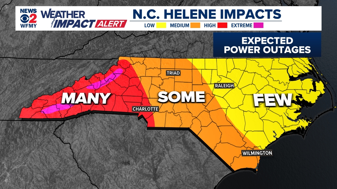
Gusty Winds and Power Outage Potential
Winds will mainly be an issue across North Carolina on Thursday night, Friday morning, and midday Friday. They will vary greatly across the state.
The highest winds in this storm will happen across western North Carolina and the Blue Ridge Mountains. Gusts there will exceed 55 to 65 mph at times.
In the Piedmont, wind gusts will largely be in the 35 to 45 mph range with occasionally higher gusts.
Farther east, winds are less of a concern.