

GREENSBORO, N.C. — UPDATE: We have a new live blog dedicated to tracking Hurricane Helene through the Carolinas.
We are here to provide live updates of what is happening in the Triad and surrounding areas as Helene makes way to the Carolinas.
LIVE UPDATES:
8 a.m.: Tornado Watch issued.
7:30 a.m.: The storm is continuing to pass through North Carolina. Several counties are reporting power outages. Starting at 8 a.m., you may experience high wind gusts and heavy rain.
6:30 a.m.: Rain is on the way to the Piedmont as Hurricane Helene passes through the Carolinas.
6:18 a.m.: Duke Energy reported there are about 1,000 power outages near Mebane and surrounding areas, as of 5 a.m.
6:00 a.m.: The worst of the storm is expected to impact the Piedmont between 8 a.m. and 12 p.m. There may be gusty winds, rain, some power outages, and a tornado threat.
5:27 a.m.: Wind gusts are predicted to become stronger throughout the morning.
5:05 a.m.: Latest temperatures across the Piedmont.
5 a.m.: Update from Downtown Boone
3:55 a.m.: A loop of how our big rain bands with wind gusts will pick up over the next several hours.
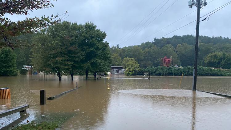
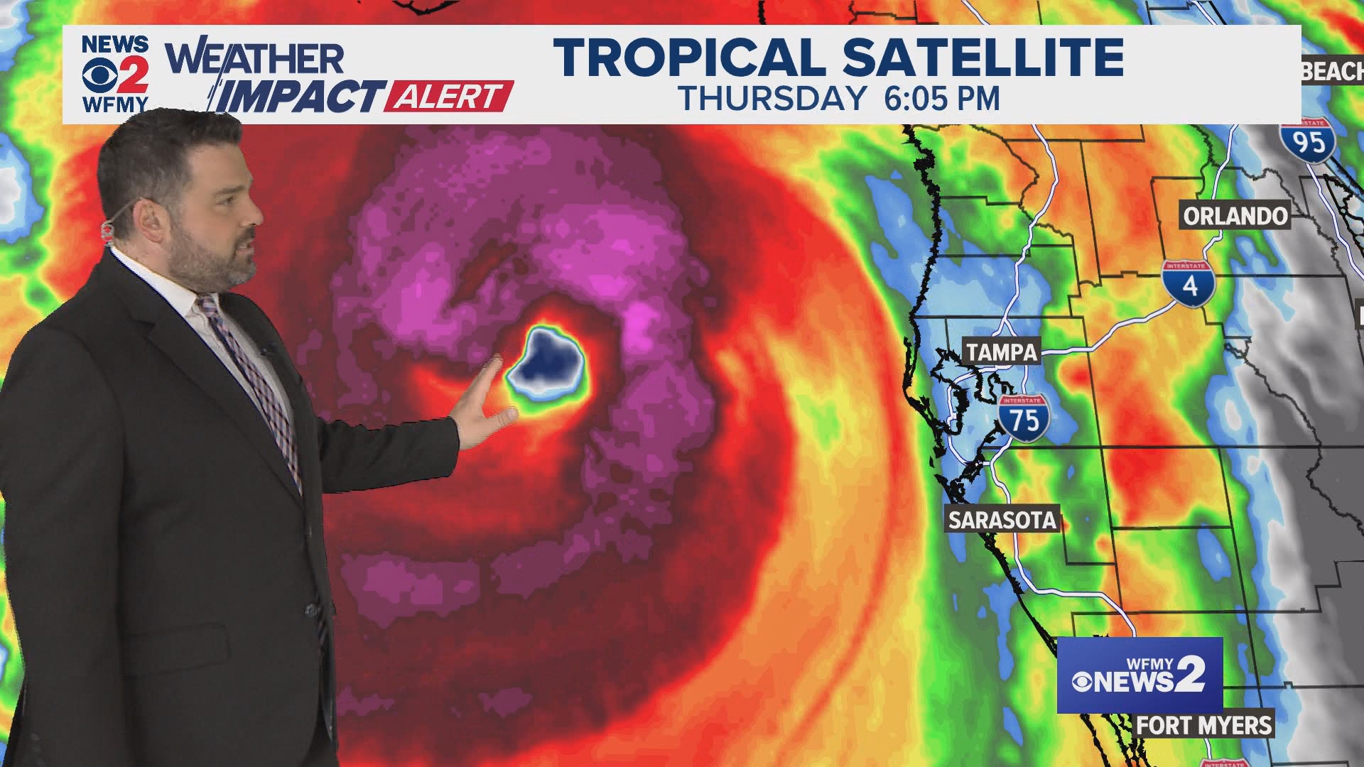
3:30 a.m.: Flooding in Tampa Bay, FL.
1:42 a.m.: Futurecast rain bands with wind gusts overlaid.
1:00 a.m.: Projected rain bands through midday Friday
12:53 a.m.: You can go to bed without too much worry here in the Piedmont.
12:00 a.m.: Detailed storm briefing from Chief Meteorologist Tim Buckley
11:06 p.m.: 76 mph wind gust in Perry, FL.
10:56 p.m.: A loop of how windy it will be Friday morning across the Triad and Piedmont areas.
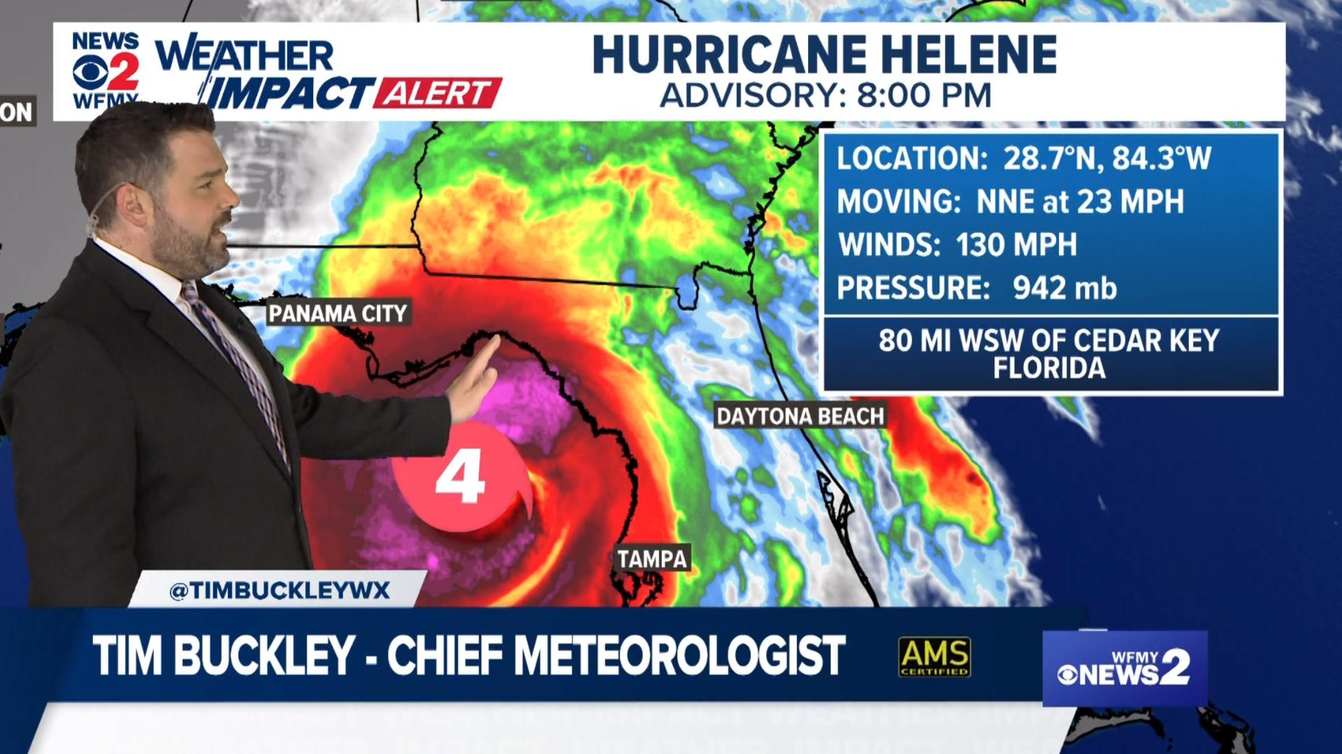
10:20 p.m.: Wind numbers as Helene comes ashore in Florida
9:13 p.m.: Tornado warning expired for Caswell Co.
8:52 p.m.: Tornado warning continues in Caswell County until 9:15 p.m.
8:28 p.m.: Observed tornado south of Anderson, NC
8:14 p.m.: Tornado warnings issued for Rockingham and Caswell counties.
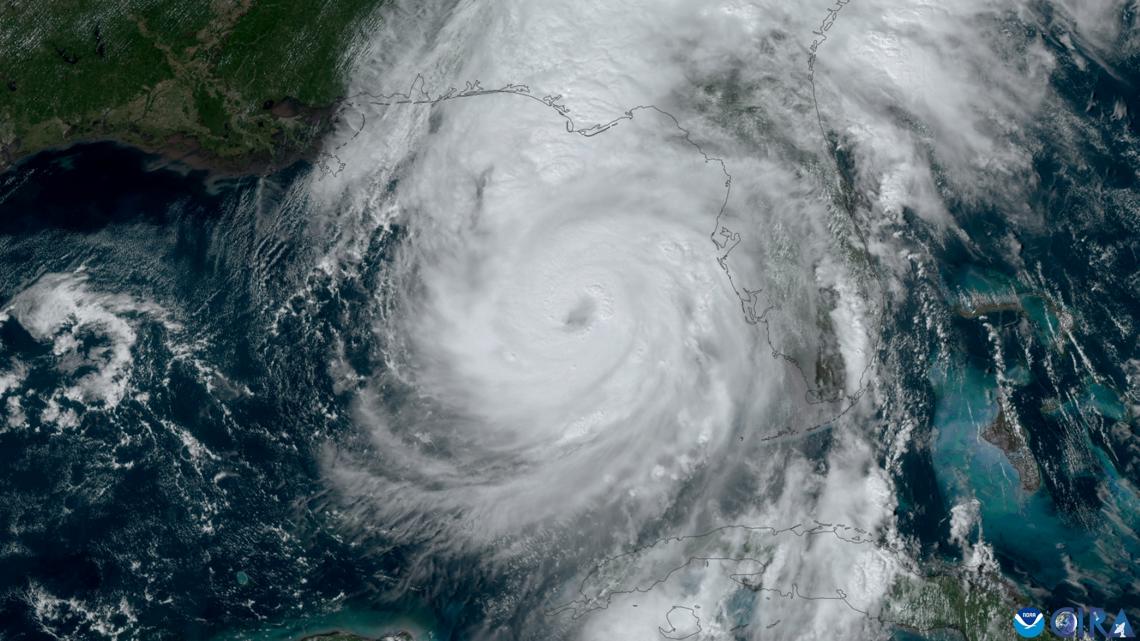
Helene is now a Category 4 major hurricane and is expected to bring a tornado risk to the Carolinas.
Hurricane Helene is on the way. Ahead of the storm, steady rain is already with us throughout our Thursday. This rain will continue through the evening and take a little break overnight.
Wind gusts aren't an issue right now, but they will pick up overnight into Friday morning. Gusts of 35-45 mph will be common on Friday morning from sunrise through early afternoon.
The WFMY News 2 Weather Team is tracking the threat of Hurricane Helene. They've issued a WFMY News 2 Weather Impact Alert Day for possible flooding and power outages on Friday.
THURSDAY
Thursday will be fairly calm most of the day with mostly cloudy skies and a scattered shower. That will start to change by the evening hours as Hurricane Helene heads inland into Florida and Georgia to our west. Our Futurecast brings some of the earliest rain into our area by dinnertime and evening. Winds won't be too gusty at this time.

Gov. Roy Cooper urged North Carolinians to prepare for Hurricane Helene during a briefing on Thursday. He referred to the storm as "unusually dangerous" and said it could potentially bring catastrophic flooding tonight and tomorrow.
The storm is also expected to bring landslides to the western part of our state. The governor's office warns residents to be prepared for thunderstorms, heavy rain, and possible tornadoes.
WHAT TO EXPECT FRIDAY
The WFMY News 2 Weather Team has declared a Weather Impact Alert Day for Friday, Sept. 27.
This is because Hurricane Helene is on the way. It will move into the Gulf of Mexico, and likely land on the Florida panhandle as a major hurricane on Thursday evening. Rain and wind from the storm are likely to be in Piedmont on Friday.
PREPARATION
Fire departments across the Triad are preparing to send rescue teams out to the mountains and the western parts of North Carolina ahead of the storm to assist with flooding in those areas.
The Greensboro Fire Department sent their urban search and rescue team to Brevard, North Carolina last night and they are remaining on stand-by to move to wherever the impact is. They specialize in search and rescue and other structural collapses.
- Winston-Salem/Forsyth County Schools will be closed for students and staff Friday. All extracurricular activities are canceled.
- Surry County Schools are closing at 2 p.m. Thursday with no after school programs and Friday will be a remote learning day.
- Stokes County Schools will have remote learning Friday.
- Wilkes County Schools are closing at 1 p.m. Thursday with no after-school programs. Friday is an optional teacher work day.
- Alleghany County Schools are dismissing at 12:30 p.m. Thursday and will be closed Friday. All afternoon activities Thursday and Friday are canceled.
- Guilford County Schools closed Friday; no remote learning.
- Rockingham County Schools closed Friday.
- Lexington City Schools closed Friday; remote learning day for staff and students.
- Mount Airy City Schools closed Friday; all after school activities canceled for Thursday.
- Alamance-Burlington School System closed Friday.
- Davie County Schools will have a remote learning day Friday; all preschools will be closed.
- Randolph County Schools closed Friday.
- Montgomery County Schools closed Friday.
- Caswell County Schools closed Friday, remote learning for staff and students.
- Thomasville City Schools
- Asheboro City Schools
MORE WAYS TO GET WFMY NEWS 2
Download the WFMY News 2 APP from your Apple or Google Play store.
ADD THE WFMY+ APP TO YOUR STREAMING DEVICE
ROKU: Add the channel from the ROKU store or search for WFMY.
Amazon Fire TV: Search for WFMY to find the free app to add to your account. You can also add the app directly to your Fire TV through your Amazon account.