GREENSBORO, N.C. —
Stay Weather Aware, "Major system" on the way
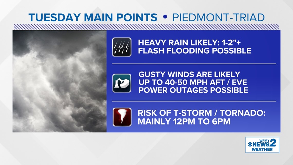
A major weather system is moving through the Carolinas on Tuesday. We are expecting rain for much of the day, with high rain totals. Winds will start low but get high by the afternoon and evening which could cause problems. On top of all that, severe thunderstorms are possible and even a threat for a few tornadoes across the Carolinas.
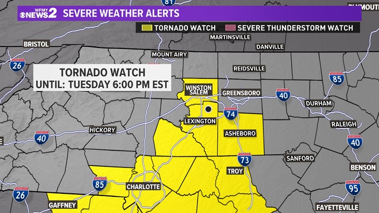
A Tornado Watch has been issued for part of the Triad including Forsyth, Davidson, and Randolph counties until 9 p.m. this evening. Make sure you are staying weather-aware!


This wet, and stormy weather pattern is typical of the El Nino pattern bringing us very wet weather. Still, this storm is particularly strong.

Heavy Rain and Flooding
We're expecting a lot of rain with this storm. It's bringing a lot of moisture from the Gulf of Mexico as it heads our way from Texas.
Rain will start early on Tuesday morning, light at first. Throughout the day, rain will get heavier. It will be heaviest during the afternoon when the possible t-storms move through our area.
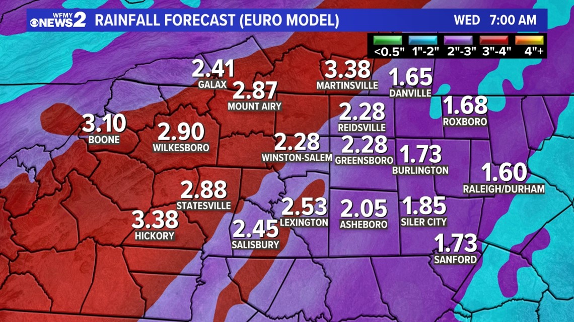
On average, it appears that a widespread 1 to 2 inches will fall in our area. Some could get as much as 3 inches. That's enough rain to cause flooding problems;.
A Flood Watch has been issued for our area for the whole day on Tuesday. It's important to remember not to ever drive through flooded roadways. Here's one model's prediction:

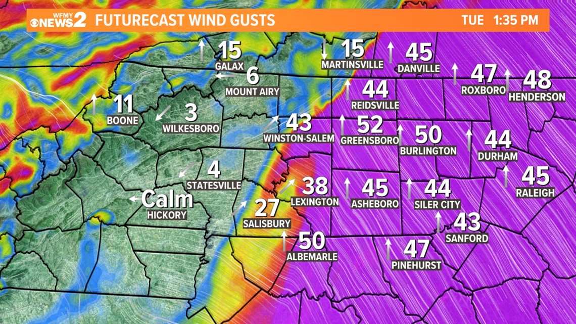
High Winds and Power Outages
It will not start out windy on Tuesday morning. However, as the day wears on and the temperature rises it will get windier. The afternoon and evening and overnight look to be the windiest times.
Wind gusts of 40+ mph are possible Tuesday after with the heavy rain moving through. Higher winds are more likely from the Triad east, and less likely from the Triad to the west where it stays cooler. Gusts of 30-40 mph will linger for everybody overnight while you're trying to sleep.
The risk of power outages is higher than usual for our area given the wet ground and duration for high winds.

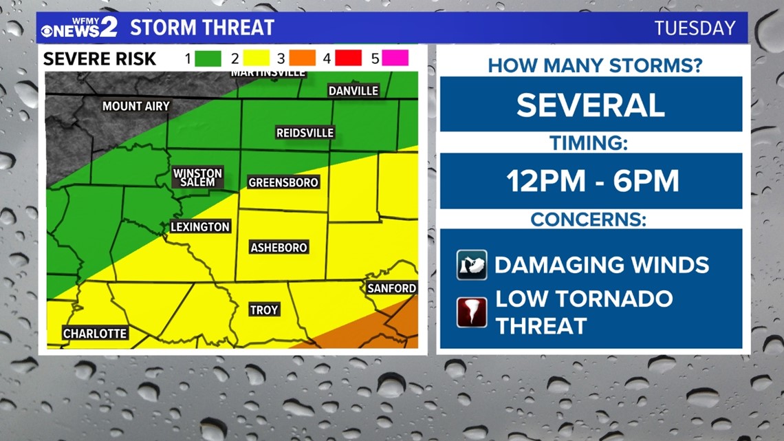
Severe Thunderstorm Threat
With warmer air and more moisture moving into our area on Tuesday, there will be a risk of a few strong or severe thunderstorms during the afternoon and evening. As the front moves through, it could spark a few of these in our region.
It will be more likely farther south and east of the Triad, especially toward the Eastern and Coastal Carolinas.
As of now, the threat level is low (level 1) northwest of Greensboro. Medium (level 2) southeast of Greensboro, and high (level 3) toward the Sandhills and coastal plain.
Damaging winds, flash flooding, and a tornado threat will be possible.

Any Snow Soon?
Snow is not in the forecast for our area over the next week or so. Keep checking back as we go through the winter months.
Stay tuned to WFMY NEWS 2 and your WFMY Forecast Team for updates. We will fine-tune the forecast as we get closer to this weather event Tuesday through Tuesday evening.
WAYS TO GET WFMY NEWS 2
Subscribe to our daily newsletter Let’s Get 2 It!
Download the WFMY News 2 APP from your Apple or Google Play store.
ADD THE WFMY+ APP TO YOUR STREAMING DEVICE
ROKU: Add the channel from the ROKU store or by searching for WFMY.
Amazon Fire TV: Search for WFMY to find the free app to add to your account. You can also add the app directly to your Fire TV through your Amazon account.
TEXT US!
Text the word WEATHER to 336-379-5775 to get the daily forecast.
Text the word APP to get a link to download the free WFMY News 2 app to your phone.
Text the word TRAFFIC to get the latest road conditions in your area.