The most bone-chilling blasts of cold air experienced in the United States can be blamed on a weather phenomenon that typically dominates a region nearly 3,000 miles away -- all the way north up in the North Pole. Bitter cold early in 2018 sent AccuWeather RealFeel® Temperatures plummeting into extreme territory in the Midwest -- as low as minus 77 F. That painful cold blast and one of the coldest winters in recent decades, the winter of 2013-14, can be traced back to the polar vortex.
The term polar vortex became a household term after these major cold spells, and there is generally an understanding that this weather feature can be responsible for sending extreme cold air into the U.S. How exactly the system helps to direct Arctic outbreaks into the country is likely not as well known.
The polar vortex is a large storm that dwells in the middle and upper parts of the atmosphere and typically resides around the Arctic Circle.
During the cold season in the Northern Hemisphere, the polar vortex generally strengthens near the North Pole. Storms, including the polar vortex, tend to form near a temperature contrast zone, which in turn fuels a strengthening during the winter.
"The temperature difference between the tropics and the Arctic Circle increases due to the lack of sunlight over the polar region during the fall and early winter season, and this is what causes the polar vortex to strengthen," Paul Pastelok, AccuWeather's lead long-range forecaster, said.
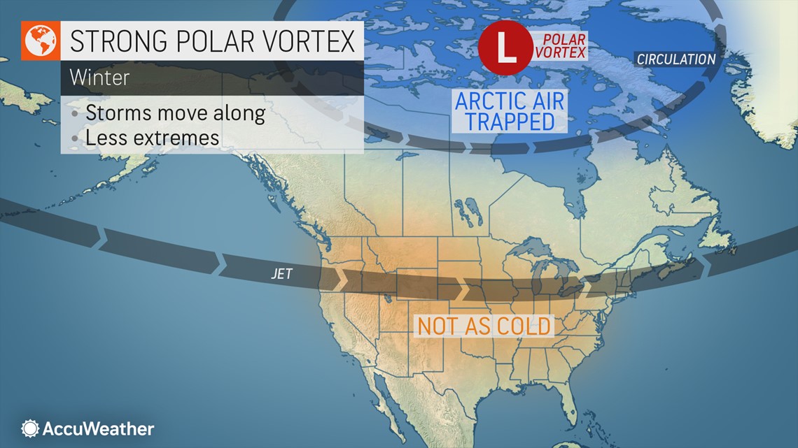
When the polar vortex is very strong, westerly winds circulating around the Arctic Circle also remain strong and tend to keep the coldest air locked up near the North Pole.


Typically, when there is a strong polar vortex to the north, westerly winds flow across much of the U.S. and southern Canada (around the mid-latitudes between 30 and 60 degrees north). However, sometimes storms over these regions can become strong enough to disrupt and bend the westerly winds.
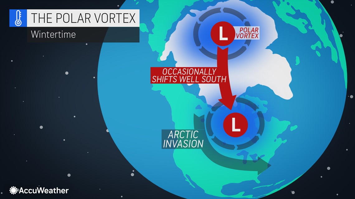
"Storms can become strong enough that they can pump warmer air northward and can weaken the polar vortex, causing the strong belt of winds around the Arctic Circle to weaken. When this happens, the chain reaction can be to allow Arctic air to escape southward and reach the mid-latitudes," Pastelok explained.


Even though storms over the U.S. and Canada can cause temperature fluctuations with occasional warm surges and brief pulses of Arctic air, the polar vortex must really weaken for major outbreaks of Arctic air that last for several days or weeks.
"When this weakening is fairly extreme, a lobe or multiple lobes of the vortex itself can bend southward toward the U.S./Canada," Pastelok said. "It is the weakening of the vortex that allows the Arctic air to be displaced."
Every weakening of the polar vortex and its associated Arctic outbreak are different. Some outbreaks can fade as the vortex first weakens and then stabilizes or strengthens. Other bitterly cold outbreaks can intensify as a marginally weak vortex becomes even weaker, allowing a major southward displacement of Arctic air.
While the vortex can weaken and direct Arctic air into the eastern U.S., at other times Arctic air may be forced farther west over the Central states or even west of the Rockies. A weak polar vortex can also direct Arctic air across the United Kingdom, central and eastern Europe and northern Asia.
AccuWeather meteorologists are constantly monitoring weather conditions around the globe for clues on upcoming patterns -- including any potential indications that signal a weakening of the polar vortex in the coming days, weeks or months. Meteorologists call some of the signals they keep a close eye on teleconnections.
"It is a matter of connecting the dots sometimes. Certain seasonal teleconnections can determine how often and the time of the year that these severe cold surges from a weakening of the polar vortex [may] occur," said Pastelok.
One of the phenomena AccuWeather meteorologists watch for occurs very high in the part of the atmosphere called the stratosphere, which is several miles above the Earth's surface. Research has shown that when there is a sudden surge in temperatures in the stratosphere around the Arctic Circle, an opposite, sudden cooling effect occurs over the lower part of the atmosphere. This can signal to meteorologists that the polar vortex is about to weaken. The whole process may take roughly one to two weeks to evolve.
"For the winter of 2020-21, research and teleconnections told us that the polar vortex would be rather strong through midwinter, which suggests limited intrusions of Arctic air," Pastelok stated.
"There are some signs pointing toward a weakening of the polar vortex toward January with a possible Arctic discharge," Pastelok explained. But, he added, a weakening of the polar vortex is more likely to happen late in the winter, which could spell cold weather outbreaks in March.
Earlier in 2020, the polar vortex dipped down over northeastern Canada in April, causing Easter in many parts of the U.S. to look more like Christmas.
And back in 2018, fierce cold gripped portions of the Midwest and East under the influence of the polar vortex. The intense cold turned deadly as thousands faced power outages amid the extreme cold, which was brutal enough to threaten frostbite in a matter of minutes. Flights were canceled in major cities like Chicago and Minneapolis as the deep freeze shattered record lows -- some of which had stood since the 1800s.
The winter of 2013-14 may have faded from memory for millions of Americans, but it was one of the coldest winters in recent decades, especially across the north-central United States. Temperature departures plummeted as low as 7 to 11 degrees Fahrenheit below average for an extended period from December through March. The invasions of Arctic air were due to frequent southward extensions of the polar vortex.
Forecasters loosely define a cold winter as one marked by temperatures averaging 2-3 degrees below normal for the season. When temperatures are several degrees different than normal for a month, it is abnormal, but when temperature departures are several degrees lower than a seasonal average, it is considered extreme.
International Falls, Minnesota, which is nicknamed the ice box of the nation due to the extreme cold the area can endure during winter, lived up to its moniker that season. Temperatures plummeted 11.7 degrees below average for the four-month stretch from December through March. To put that in perspective, the normal high temperature during early to mid-December there is 15 F -- and the normal low temperature is minus 7.
In Minneapolis, the temperature departure during the same four-month period was 8.5 below normal. In Chicago, temperatures averaged 7.3 below normal, and in Detroit. the departure was 7.4 degrees. The frequent cold was felt much farther south and east as well that winter with departures of 2-3 degrees below average experienced in Dallas, New Orleans, New York City and Boston.

