
GREENSBORO, N.C. — It's been hot, but it's going to get hotter for Friday. A combination of high heat and high humidity will raise our heat index to a dangerous level - making it tough to be outside during the afternoon and evening. The WFMY News 2 Weather team is issuing a WFMY News 2 Weather Impact Alert day for Friday to give a heads-up about the heat. We are also expecting some late-day thunderstorms. Here's what we're tracking.
Dangerous heat & humidity
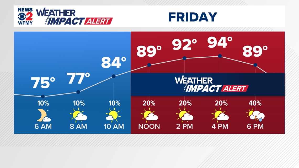
We've seen a return to hot weather over the last few days. After hitting the 90s for a couple afternoons, Friday will be our hottest day of the week. We are forecasting high temperatures to range between 93 and 97 degrees across the Piedmont-Triad area. But, as you know, it's not just the heat.
Humidity will be very high on Friday as well with dew point temperatures in the 70s. This humidity makes it harder for our bodies to cool down as they naturally would, adding stress to our systems.
It will feel like it's between 100 and 105 degrees throughout the Friday afternoon and evening hours. This can be a dangerous level of heat and humidity to deal with for our bodies. It's smart to take frequent breaks in air conditioning and stay hydrated if working outside.
A Heat Advisory has been issued for the eastern half of our area from 11 a.m. to 8 p.m. for Friday.

Late-day thunderstorms likely too
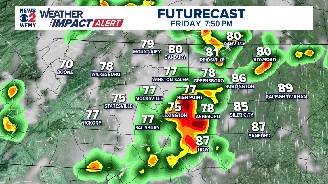
On top of the heat and humidity, some thunderstorms are likely to move toward and cross the Piedmont for the late afternoon and evening. These boomers could pack a bit of a punch for some of us.
With the amount of heat and humidity, there will be a lot of fuel for these storms to grow in size as they head our way.
We are expecting a line of storms between 3 p.m. in the west and 9 p.m. in the east.
Some of the storms could have a damaging wind gust or two on top of torrential rain, lightning, and small hail.
It's important to keep an eye on the radar and be "storm ready" to make sure you're not putting yourself or your family in harm's way outside. The WFMY News 2 app has a great interactive radar you can use for free 24/7 to keep ahead of the storms.
The threat for severe weather is a 1 out of 5 for Friday afternoon, mostly for damaging wind gusts.

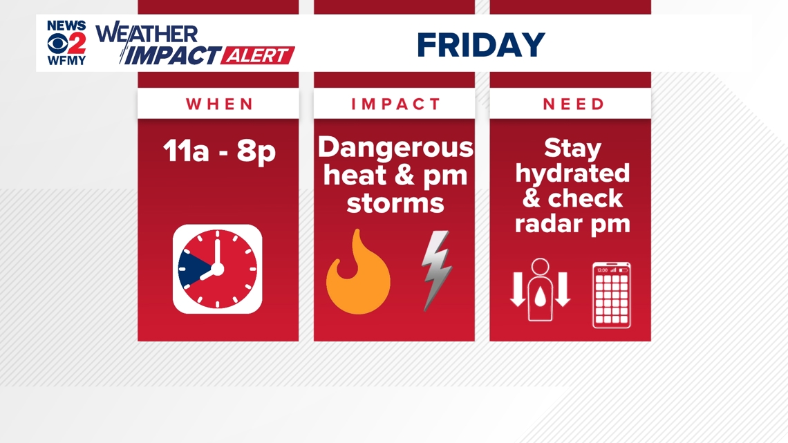
Weather Impact Alert Day
To recap, we are expecting some dangerous levels of heat and humidity on Friday.
This is most likely between 11 a.m. and 8 p.m.
It's important to stay hydrated and to take breaks in air conditioning if you have to be working outside Friday.
We will also see thunderstorms between 3 p.m. and 9 p.m. Make sure if you hear thunder to head indoors. Use the WFMY News 2 radar app to help track the storms wherever you are.

Stay safe in the heat
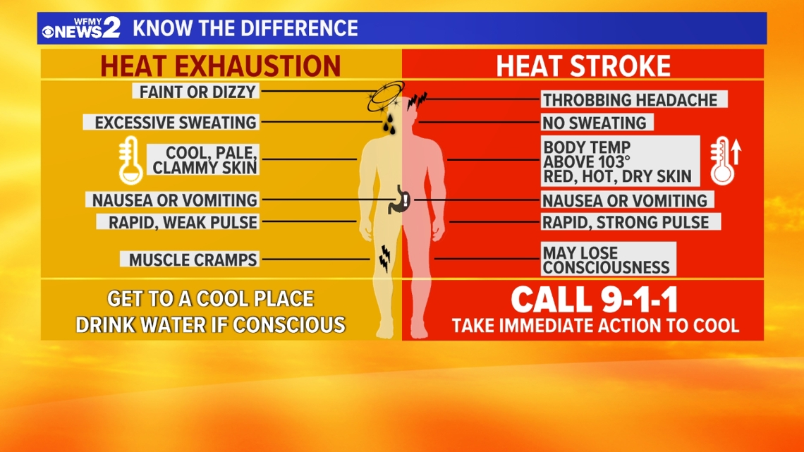
It's important to know the difference between heat exhaustion and heat stroke. This can save lives during hot weather. The differences are spelled out below.