GREENSBORO, N.C. — The leaves are falling, which means winter is just around the corner. It's time to look ahead to what the winter season may bring. It's been a while since we've had much of anything here in North Carolina. The WFMY News 2 Weather team has been crunching the data and analyzing this year's weather pattern and tells us what to expect.
It's Been a While!
There's more to winter than snow, but around here winter has featured anything but snow recently. We are in the middle of the second-longest snow-free streak on record.
The last time that snow fell (and stuck) in the Piedmont was back in January of 2022. That's a streak of over 1,000 days. We had about 2 or 3 small snow events.
The longest streak on record is from December 1989 to February 1993 of 1,169 days. Will this year be any different?
Let's dive into the pattern this year.
Going from El Niño to La Niña
You hear us talk about El Nino a lot when it comes to winter weather forecasting. That's when the water in the Pacific Ocean near the equator is warmer than average. It has an impact on global weather patterns and can often give us a better chance for snow. That's the pattern we were in going into last winter. Even with that, we weren't able to get any snow systems.
This year, we're not in an El Nino - we're expecting the opposite. It's known as a La Nina when the water in the Pacific near the equator is cooler than average. This also has impacts on the global weather pattern, with opposite effects.

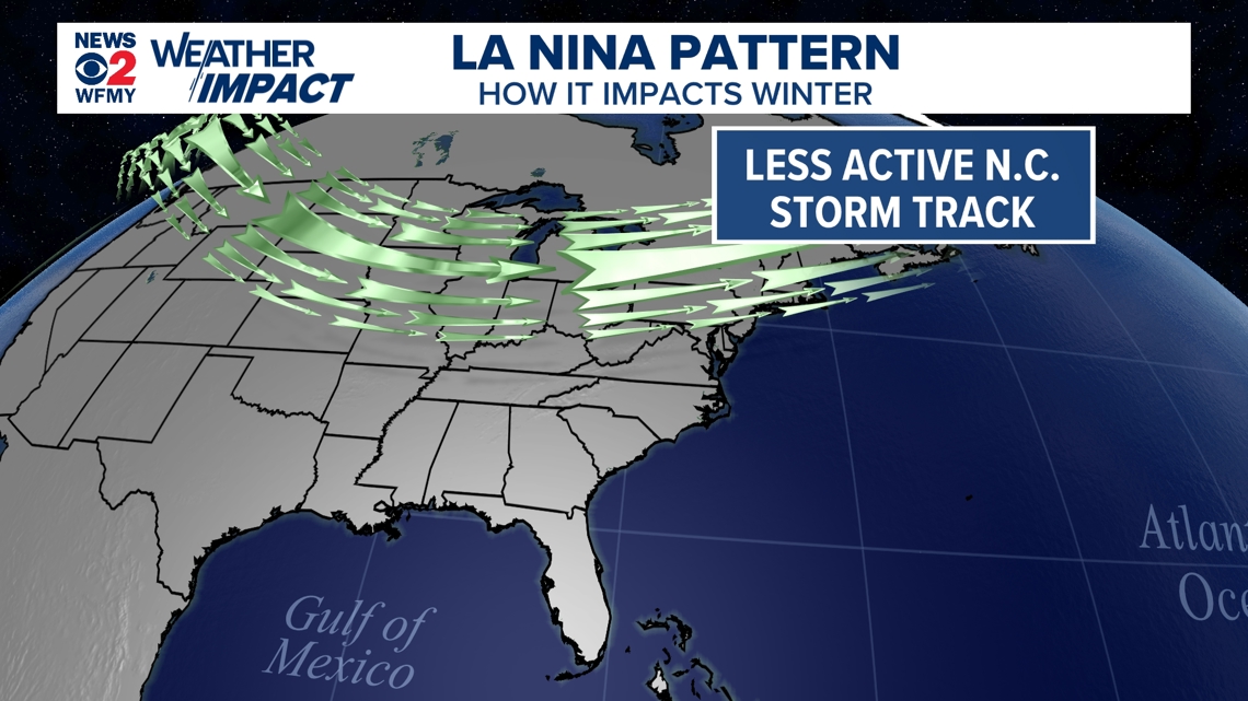
The main impact from a La Nina is that it usually pushes the jet stream farther north. This means that as storms roll across the country they often aren't coming into the Southeast as often. With a less active storm track it can be harder to get as much rainfall, and snowfall. It can also result in limited Arctic outbreaks and less cool air.
How Did Past La Nina Winters Go?
It's good to use history to compare how things happened before to see how things may happen going forward. In this case, we looked at a dozen winters that featured a weak La Nina pattern - which is what we expect to develop this winter as well. We gathered this data for temperatures, rainfall, and snowfall. Here's what we found.

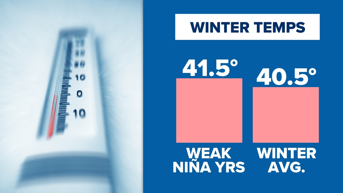
Using data from 12 different weak La Nina winters the pattern for temperatures was not a strong one. On average, the La Nina winters were about 1 degree warmer than average. While the odds may favor a slightly warmer than usual winter, that wasn't always the case in these years.
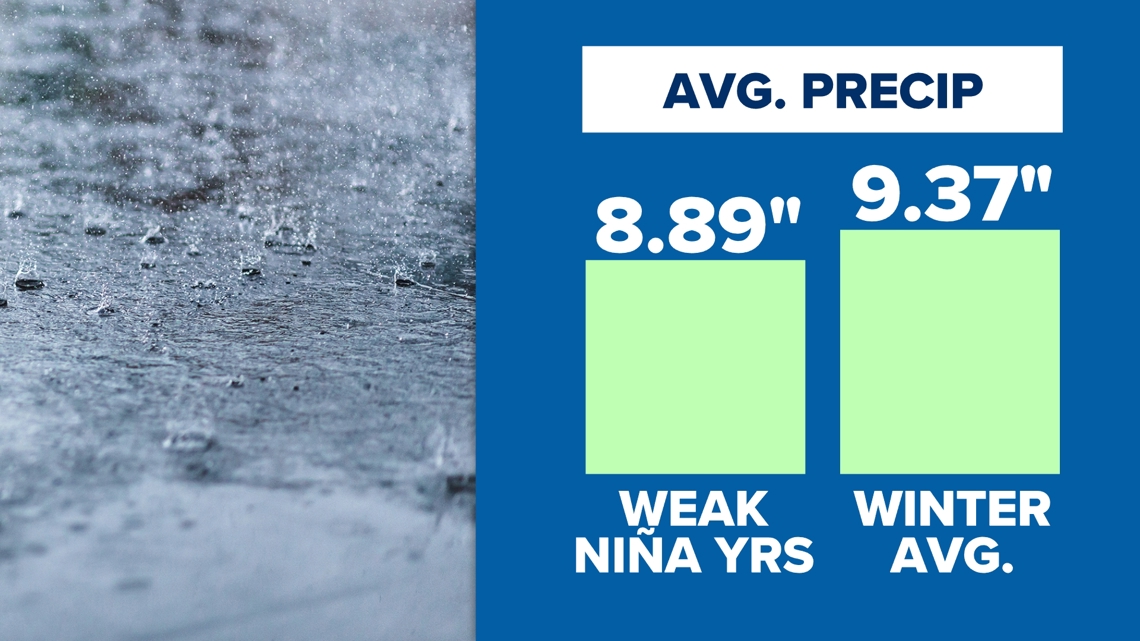
With precipitation a small trend was found, pointing to slightly less wet winters during the weak La Nina years. Notice below there's less than a half-inch difference in the data. Odds would favor a slightly drier winter, which makes sense given that the jet stream is typically farther north in these years.

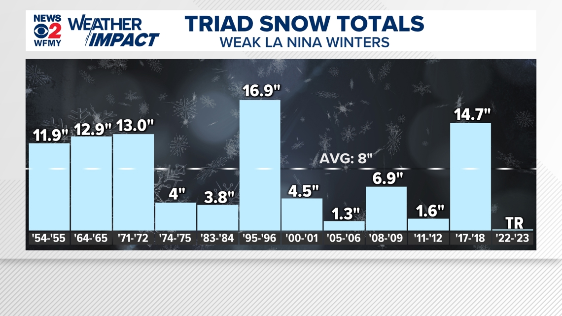
With snowfall, there's a lot more variability. Snow in the south isn't very common, so we often have fewer data points to go on. One or two storms can make up a whole season! Let's take a look at what the data show.
In weak La Nina years we see some that saw plenty of snow with others that had hardly any at all. Even in recent years, 2017-2018 brought big snow to our region as you might remember. However, in 2022-2023 we recorded only a trace of snow.
Overall, the snow average was less in weak La Nina winters. Consider also that 3 of the snowy winters were a few long time ago in the 1950s, 1960s, and 1970s.

Other Factors To Consider
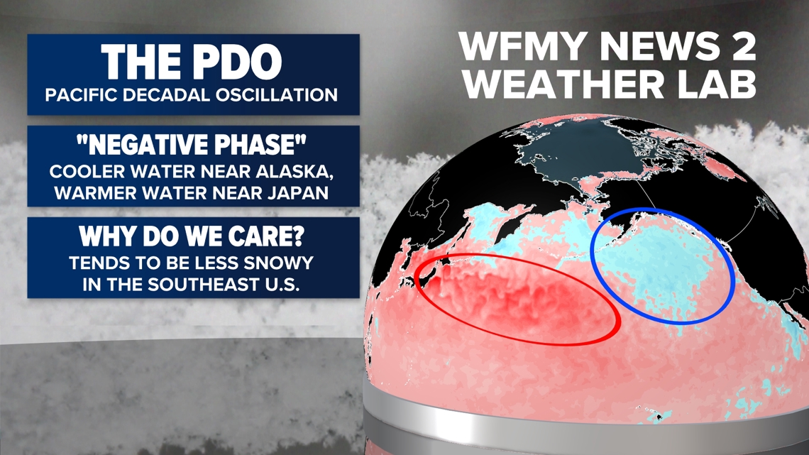
There are many other tools for long range weather forecasting. Without going through the whole list we do want to point one out. It's called the PDO, or Pacific Decadal Oscillation. All you need to know is that it's another temperature pattern in the Northern Pacific Ocean.
This is a pattern that can last for years or even decades. When the water is cooler than average near Alaska and warmer than average close to Japan that's called the negative phase of the PDO. We've been in this negative phase since 2019.
In general the negative PDO makes it tougher for snow storms to impact the eastern United States. Sure enough, there has been a major lack of snow activity in the Eastern US and the Carolinas since 2019, with only a few exceptions.
When combining this with our weak La Nina setup it does give some confidence to it being a drier, and less snowy winter than usual.

Winters are Warming
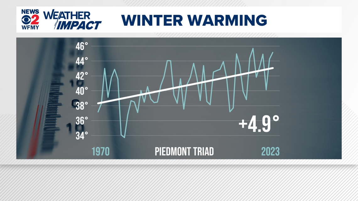
Over a long period of years we can identify trends in our data. Looking at the Piedmont-Triad area over the last 5 decades there has been some clear warming to the winter season.
In fact, temperatures have warmed about 5 degrees since the 1970s during the winter season. That isn't to say it doesn't get cool or cold, but outbreaks of Arctic air are less common and less extreme than it used to be. This can make it a bit harder to cash in on snowfall than it used to as well.

So What's the Winter Forecast?
We've talked about a lot of factors. We're heading into a weak La Nina pattern, we have a negative PDO, and our winters have been warming a bit over time.
Considering all of that, here's our forecast:
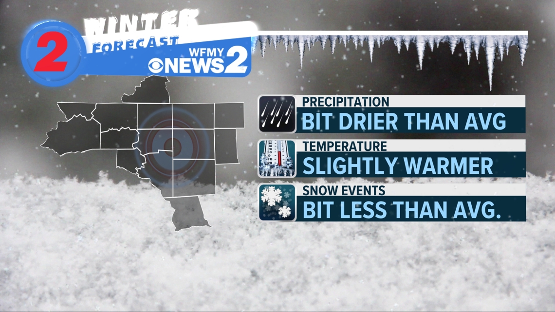
- Temperatures: We're expecting a winter that is slightly above average. It will still feel like winter, but less cold air than usual.
- Precipitation: We're expecting a winter that is slightly drier than average. We will still have rain at times, but odds favor a drier winter.
- Snowfall: Snow is hard to forecast in the long range. Still, odds favor fewer snow events than usual. We are expecting less snow than usual. (Average is 7-8 inches for the Piedmont) It is very hard to get a snow-free winter like we've seen recently so there is still a good chance of having at least some snow this year.

